
| Image | Software Module | Description |
|---|---|---|
|
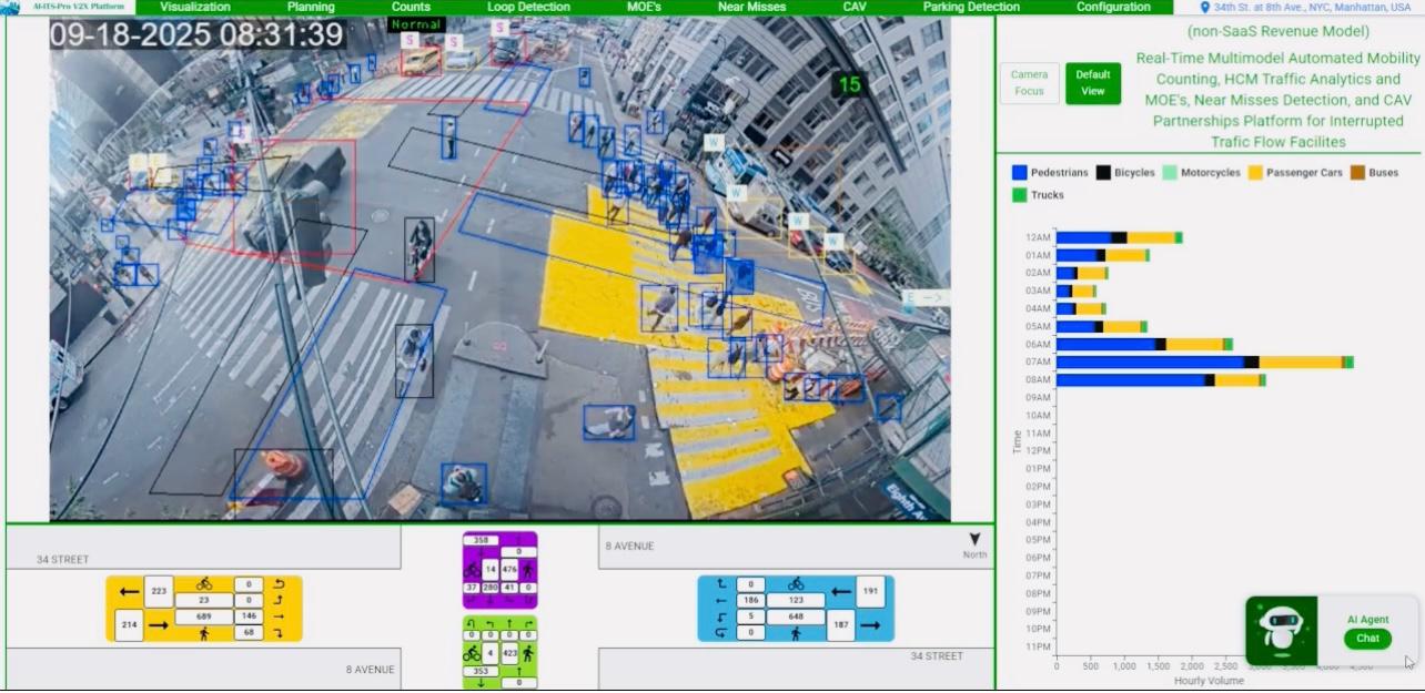
Signalized Intersection Real-Time Multimodal Automated Mobility Data Collection |
Real-Time Multimodal Automated Mobility Data Collection (turning movement counts,
volumes per lane, vehicle classifications, pedestrian, and bicycle crossing), Data
Reduction in Tabular and Graphical Format, and HCM 7th Edition Capacity Analysis,
Traffic Analytics with Accuracy >95% during Daytime, Nighttime and All Adverse Weather
conditions. It produces daily excel output files for planning and design comprising
multimodal data base, vehicle classifications, reduced data for peak periods, peak
hours, off peak periods, off peak hours in tabular and graphical formats with estimated
PHF, queue length and v/c ratios with converted CSV files to export data to Synchro and
VISSIM software. The dashboard illustrates real-time turning movement counts,
pedestrians count, bicycles count, queue length, and dynamic capacity analysis estimates
in rolling 15 minutes intervals (v/c ratio) by movement, lane group, approach and
overall.
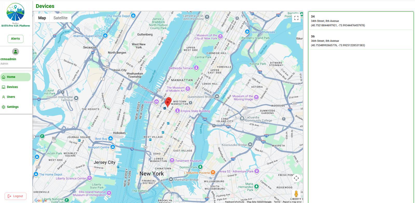
The Intersection of 8 Avenue at 36 Street, New York, NY - Visualization – Data Collection - Data Reduction – HCM Capacity Analysis and MOE's |
|
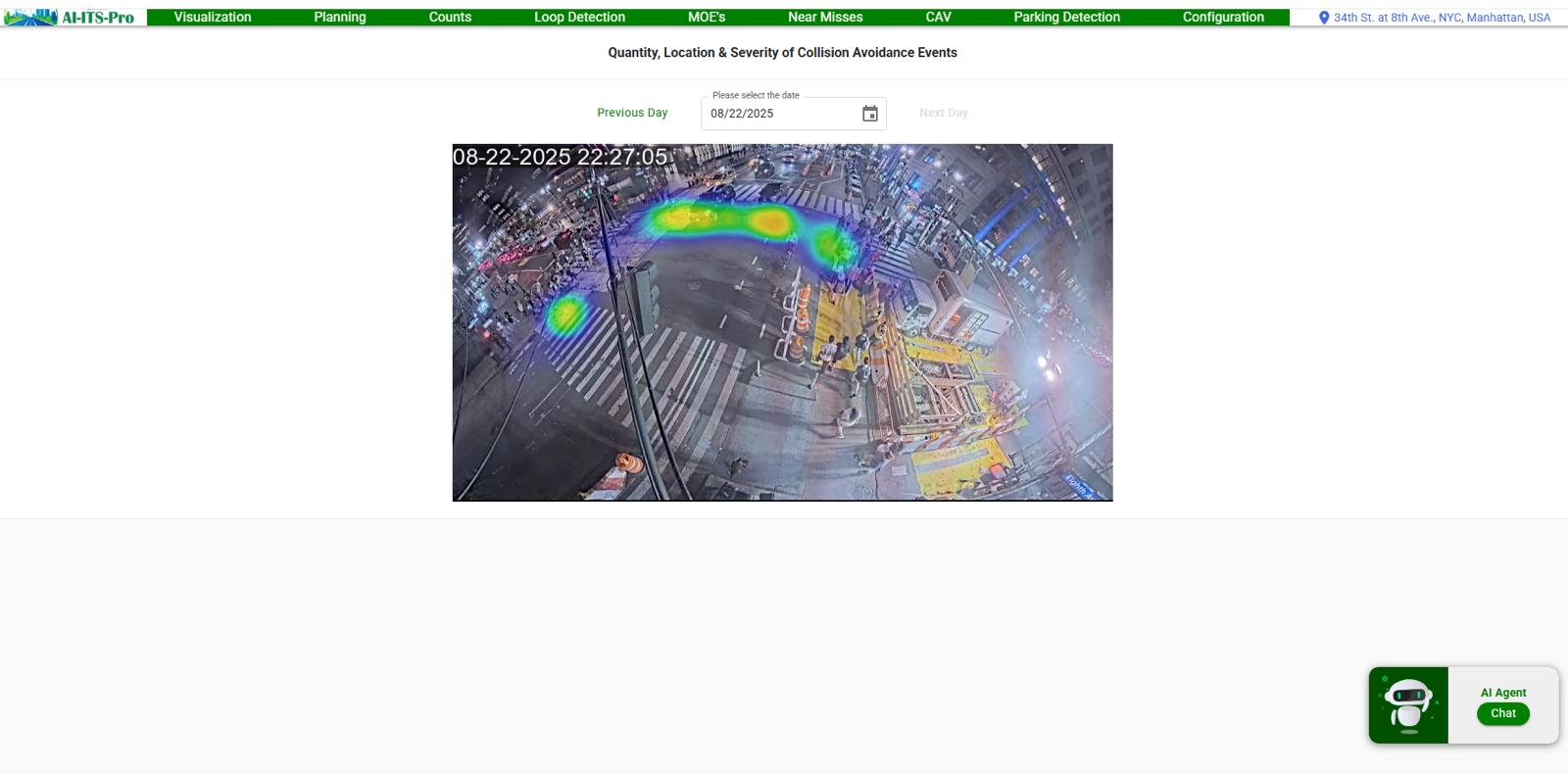
Intersection Collision Avoidance & Safety Investigation |
By constantly analyzing the flow and behavior of traffic, the system can detect patterns
indicating a potential collision risk, such as sudden changes in vehicle speed, erratic
lane changes, or unusual congestion. Once identified, alerts can be sent in real-time to
traffic management centers, nearby vehicles equipped with vehicle-to-infrastructure
(V2I) technology, or even to drivers' smartphones via a dedicated app, facilitating
immediate preventive action. Machine learning algorithms can use real-time data to
forecast potential future traffic incidents. If a particular intersection is known to
have frequent near-miss incidents at specific times, predictive analytics can foresee
high-risk scenarios. Preventive measures can then be taken, like altering traffic signal
patterns and V2X Technology warning drivers to be extra cautious in the predicted
timeframes. The system's capability to detect and tally pedestrians and bicycles is
vital for their safety. It can prompt extended walk signals, exclusive crossing phases,
or driver alerts in areas with heavy foot and bicycle traffic, enhancing safety. In case
of a collision, the system swiftly identifies and notifies users.
The Intersection of 8 Avenue at 34 Street, New York, NY - Near Misses, Collision Avoidance and Safety Investigation |
|
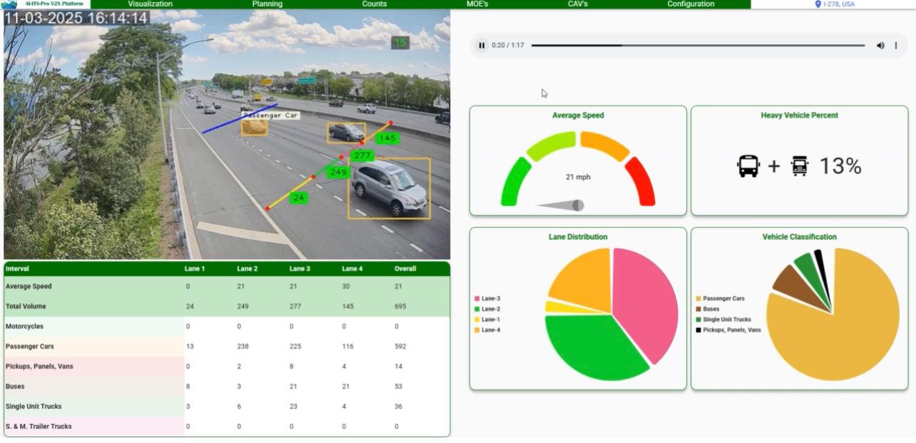
Highway (Basic segment, Merge and Diverge) Real-Time Multimodal Automated Mobility Data Collection |
Real-Time Multimodal Automated Mobility Data Collection (volumes, vehicle
classifications, and average speed by lane and total), Data Reduction in Tabular and
Graphical Format, and HCM 7th Edition Capacity Analysis and Traffic Analytics with
Accuracy >95% during Daytime, Nighttime and All Adverse Weather conditions. It produces
daily excel output files for planning and design comprising data base, vehicle
classifications, average speed, reduced data for peak periods, peak hours, off peak
periods, off peak hours in tabular and graphical formats with estimated PHF, highway
speed flow characteristics, density and Level of Service by lane and total. The
dashboard illustrates real-time average speed, volumes, vehicle classifications, dynamic
capacity analysis estimates in rolling 15 minutes intervals and highway speed flow
characteristics flow charts by lane and total for CVS partnerships.
Visualization – Data Collection - Data Reduction – HCM Capacity Analysis and MOE's |
|
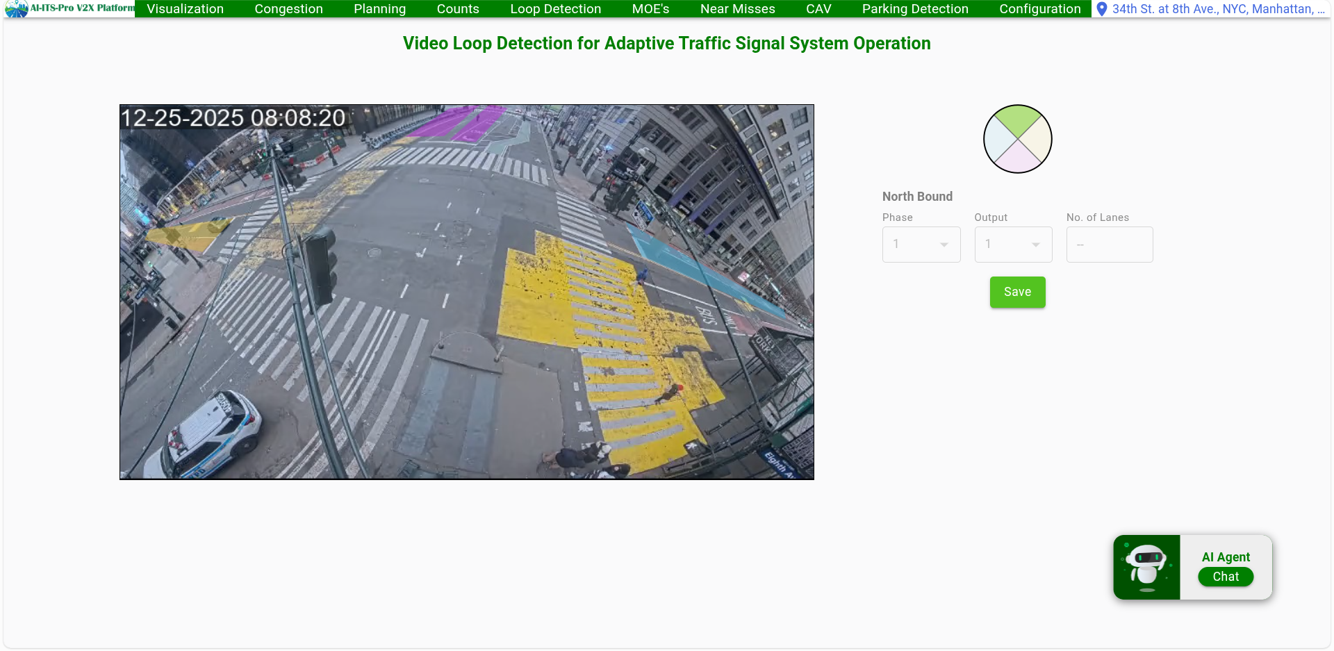
Video Loop Detection Adaptive Traffic Signal Optimization |
Advanced video loop detection system for adaptive traffic signal optimization. This intelligent system continuously monitors traffic flow and adjusts signal timing in real-time to optimize traffic flow, reduce congestion, and improve overall intersection efficiency. |
|
GIS Ready Traffic Management Software Up to 1,000 Location Capacity |
Comprehensive GIS-ready Traffic Management Software designed for Traffic Management Centers with capacity to manage up to 1,000 locations. This powerful platform provides centralized monitoring, control, and analysis of traffic systems across large metropolitan areas, enabling efficient traffic management and data-driven decision making. |